Precision Farming Systems for Yield Mapping: Key Technologies and Field Applications
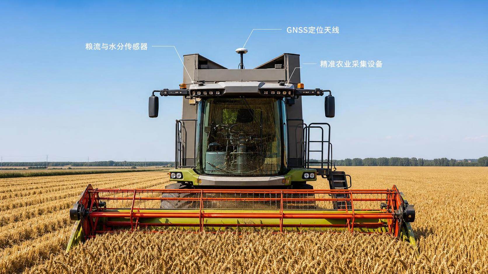




Yield mapping is only useful when its measurements can be trusted across the entire harvest workflow. A colorful map produced by a combine display is not automatically a management tool. For technical evaluation, the central question is whether the system can convert crop flow, moisture, location, and machine operating conditions into spatial data that remains consistent enough to support decisions on seed, fertilizer, drainage, irrigation, and field operations.
Precision farming systems for yield mapping combine a calibrated yield monitor, GNSS positioning, field boundary data, data logging, and analytical software. Their value is not confined to measuring yield variation. A well-designed system helps distinguish persistent field constraints from temporary harvesting effects, then links those findings to practical variable-rate or field-improvement actions.
What a Yield Map Must Represent
A yield map should represent crop yield at a known location and time, after accounting for the time it takes material to move from the header to the sensing point. That sounds straightforward, but each element introduces error. A yield sensor may measure grain flow accurately at the elevator while the GNSS receiver records the combine's current position several seconds later. Without a correct delay setting, the yield pattern is shifted across the field. On small or irregular zones, that shift can make a meaningful pattern look false.
Moisture measurement matters for the same reason. Wet grain weighs more than dry grain, so yield must be normalized to the crop's chosen reporting moisture before comparisons are made. If this correction is inconsistent, a map can reflect moisture changes during harvest rather than actual production differences.
A reliable map therefore needs four conditions:
- Stable mass-flow measurement across the expected harvest rate range.
- Consistent moisture sensing and a defined moisture-adjustment method.
- Position data with sufficient accuracy and continuity for the management resolution required.
- Proper handling of machine delays, header width, swath coverage, turns, stops, and partial passes.
Yield is also affected by harvesting losses, header performance, and changes in travel speed. A low-reading zone may indicate poor crop establishment, but it can also result from a narrow overlap, a partially filled header, slow unloading, or a sensor response problem. The evaluation process should treat the yield map as a measurement product, not as direct proof of agronomic cause.
The Technology Stack Behind Accurate Mapping
Yield and moisture sensing
Most combine-based systems estimate yield from grain flow, typically at the clean-grain elevator. The sensor output must be related to a known harvested weight through calibration. This is not a one-time installation task. Crop type, grain characteristics, flow range, machine settings, and wear can change how the sensor responds. Calibration based only on a narrow flow range may appear acceptable during steady harvesting but become unreliable at low rates, high rates, or in variable terrain.
Technical evaluators should look for a workflow that supports multi-point calibration, clear record keeping, and repeatable comparison against independently weighed loads. A monitor with advanced display features cannot compensate for weak calibration discipline.
GNSS guidance and position quality
GNSS provides the spatial reference for every yield observation. The appropriate correction level depends on the intended use. Broad management zones may tolerate lower positional precision than controlled-traffic layouts, repeatable strip trials, or year-over-year comparison of narrow drainage features. More important than a headline accuracy claim is whether the system holds its position consistently during harvest and records the correction status with the data.
Signal interruptions, correction-source changes, antenna placement, and uneven terrain can all affect map quality. The installation should also account for the antenna's offset from the header and the machine's direction of travel. A location point recorded at the cab roof is not automatically the location where the crop entered the header.
Coverage detection and machine-state data
A yield value requires context. The system needs to know whether the header is engaged, whether the machine is harvesting or turning, the active cutting width, and preferably travel speed. Automatic section or swath detection can reduce manual input, but it must handle partial-width harvesting, lodged crops, headlands, and irregular boundaries.
Machine-state signals are especially valuable when cleaning data. Header-up points, stationary points, unloading periods, reverse travel, and implausibly high speeds should usually be excluded or reviewed before analysis. Integrating telematics can help trace these events, provided the data can be exported with timestamps and aligned with the yield log.
Data transfer and spatial analytics
The final map depends on how raw observations are processed. Systems commonly collect point data at short intervals, then aggregate or interpolate it into cells, grids, or management zones. This processing can either reveal field structure or hide it. Excessive smoothing can erase narrow yield constraints; insufficient filtering can preserve noise as if it were field variation.
Software selection should therefore be assessed on traceability, not only map appearance. Users should be able to retain the raw dataset, document filtering rules, inspect removed records, define field boundaries, and export standard spatial formats. A closed workflow that produces attractive maps but limits data access can create a long-term interoperability risk.
Evaluation Criteria That Matter More Than a Feature List
Interoperability deserves particular attention on large operations with mixed equipment fleets. A yield monitor may work well on one combine but create an inefficient process if boundaries, guidance lines, crop records, and prescriptions must be converted manually between platforms. The useful unit of evaluation is the complete data path: field setup, in-cab capture, transfer, quality control, analysis, prescription creation, and application feedback.
From Harvest Data to Management Zones
One harvest map is an observation, not a prescription. Crop yield can vary because of weather timing, disease pressure, harvest timing, or a localized operational interruption. Persistent zones become more credible when patterns recur across seasons or agree with independent layers such as elevation, soil texture, electrical conductivity, drainage observations, irrigation performance, planting records, and targeted soil sampling.
Consider a stable low-yield strip. If it follows a compacted headland, wheel-track history and soil penetration measurements may be more informative than a fertilizer response trial. If it follows an elevation break, water movement or infiltration may be the likely investigation path. If it corresponds to pressure variation within an irrigated area, the next step may be checking emitter performance, pressure regulation, or irrigation scheduling rather than changing crop inputs uniformly.
This is where yield mapping becomes relevant beyond the combine. It provides a common spatial layer for intelligent farm tools, variable-rate application systems, and water-management analysis. The goal is not to make every field variable-rate by default. A field with uniform, repeatable performance may gain more from dependable records and basic operational optimization than from complex prescriptions. Variable-rate programs are justified when the identified variation is stable, operationally controllable, and economically meaningful within the farm's own decision framework.
Field Applications and Their Boundaries
Yield mapping is particularly valuable in large fields where visual scouting cannot reliably capture within-field variation. It can guide grid refinement for soil sampling, identify zones for crop trials, compare hybrids or varieties under similar conditions, and evaluate whether drainage, irrigation, tillage, or traffic-management changes altered performance.
For combine-harvested grains and oilseeds, the system can also reveal recurring patterns associated with lodging, field-edge effects, residue distribution, or equipment access routes. In irrigated production, yield patterns can be combined with irrigation zones and water-use records to identify areas that deserve closer hydraulic or agronomic review. The map should not be used alone to judge irrigation efficiency; yield is influenced by many factors, and water application data must be spatially aligned before conclusions are drawn.
Yield mapping is less dependable where harvest collection is incomplete, crop flow is highly intermittent, fields are too small for the equipment's measurement delay to be resolved, or harvest conditions prevent regular calibration checks. These conditions do not make mapping impossible, but they change its role. The data may be useful for broad pattern recognition while being unsuitable for fine-resolution prescriptions.
Common Errors That Distort the Result
The most common mistake is treating a factory-installed monitor as a finished yield-mapping system. Installation provides the hardware; calibration, field configuration, operator practice, and data cleaning create the usable dataset.
Another error is comparing maps from different years without checking crop type, moisture basis, harvest direction, map processing rules, and positioning quality. A change in color pattern may result from a change in classification settings rather than a real change in field performance. Comparison is strongest when the same data-handling rules are applied across seasons.
It is also risky to delete every unusual value automatically. Some outliers are clearly operational artifacts, but others may reveal a genuine obstruction, wet depression, poor stand, or localized crop loss. A defensible cleaning workflow flags abnormal records, connects them to machine-state information, and retains an audit trail of what was changed.
A Practical Acceptance Process
Before selecting or commissioning a system, define the decisions the maps must support. This determines the required spatial resolution, correction service, data format, and integration scope. A useful acceptance process follows a simple sequence:
- Map the equipment and software environment already in use, including combine displays, GNSS sources, farm-management platforms, and variable-rate controllers.
- Set crop-specific calibration and moisture-adjustment procedures before harvest begins.
- Validate yield records against weighed loads over more than one operating condition.
- Run a harvest-day quality review for header status, coverage, speed, missing data, and obvious positional shifts.
- Process a sample field through the intended analytics workflow before committing to a fleet-wide rollout.
- Compare the resulting pattern with field knowledge and at least one independent spatial dataset before creating prescriptions.
For operations assessing combines, tractor guidance, precision implements, and irrigation systems together, AP-Strategy's focus on machinery performance, precision-agriculture data, and water-management intelligence reflects the broader requirement: a yield map has more decision value when it can be connected to the systems that can act on it.
FAQ
How often should a yield monitor be calibrated?
Calibration should be checked whenever crop conditions, crop type, or operating range changes enough to affect grain flow behavior. A harvest season should include repeated validation against known load weights, not a single setup event at the beginning.
Can a yield map justify a fertilizer prescription by itself?
No. It can identify zones for investigation, but it does not identify the limiting nutrient on its own. Soil tests, crop history, removal estimates, and operational constraints are needed before converting yield variation into a fertilizer decision.
Is higher GNSS accuracy always necessary?
No. The required accuracy should match the decision. Broad-zone analysis may not need the same repeatability required for controlled traffic, narrow trial strips, or multi-year alignment with drainage and irrigation infrastructure.
Why do yield maps show stripes that follow the harvest path?
They may reflect actual crop variation, but they can also indicate delay misconfiguration, inaccurate swath width, overlap, inconsistent header sensing, or speed-related sensor behavior. The pattern should be checked against machine logs before it is interpreted agronomically.
Related News
Choosing an Agriculture 4.0 Supplier: Compatibility, Support, and Total Cost
Choose an Agriculture 4.0 supplier with confidence. Learn how to verify compatibility, assess support, and compare total ownership costs to avoid hidden fees and costly downtime.
Low-Pressure Drip Irrigation: How to Fix Uneven Watering Without Raising Pressure
Optimize low pressure water-saving irrigation systems: discover how to fix uneven watering, clear blockages, and reduce hydraulic losses without raising supply pressure.
Comparing Farm Equipment Supplier Quotes: Price, Freight, and Warranty
Simplify supplier comparison for farm equipment price: assess freight, field-ready costs, and warranty coverage. Learn how to avoid hidden charges and choose a reliable supplier.
Choosing a Digital Farming Platform Provider: Compatibility and Data Ownership
Compare digital farming platforms providers on equipment compatibility, data ownership, and export rights. Discover practical checks to avoid lock-in and choose with confidence.
How Large-Scale Farm Telematics Cuts Downtime Across Mixed Fleets
Large-scale farm equipment telematics cuts mixed-fleet downtime with real-time alerts, smarter maintenance, and stronger operational control. Learn how to protect critical farm workflows.
How to Size Low-Pressure Water-Saving Irrigation Systems for Uneven Fields
Low pressure water-saving irrigation systems for uneven fields: learn zoning, pressure mapping, pipe sizing, and pump selection to improve uniformity and reduce water waste.
Farm Machinery Sourcing: How to Vet Suppliers, Specs, and Lifecycle Costs
Farm machinery information for sourcing: learn to vet suppliers, compare specifications, control lifecycle costs, and secure reliable uptime for smarter equipment purchases.
How telemetry for agriculture helps identify equipment downtime
Telemetry for agriculture helps detect early warning signs, prioritize maintenance, and reduce costly equipment downtime before field operations are disrupted.
What maintenance challenges come with hybrid agricultural machines?
Hybrid agricultural machines demand smarter maintenance. Discover key challenges in high-voltage safety, batteries, software diagnostics, cooling, and parts planning.
Related News
- 00
0000-00
How to Evaluate Dynamic Feedback Algorithm Suppliers for Precision Farming Systems - 00
0000-00
How Sensor Feedback Enables Accurate Variable-Rate Fertilization in Field Conditions - 00
0000-00
How to Select Precision Crop Protection Equipment for Variable Field Conditions - 00
0000-00
How to Evaluate Precision Fertilization System Suppliers for Farm-Scale Deployment - 00
0000-00
How to Select a Precision Fertilization System for Variable Corn Field Conditions
Popular Tags
Tractor Power Architect
Weekly Insights
Stay ahead with our curated technology reports delivered every Monday.